

On this page
- Kazbegi Hiking in 2026: What’s Actually Changed on the Trails
- The Terrain You’re Walking Into
- The Gergeti Trinity Church Trail: What Most Guides Get Wrong
- Juta Valley and the Chaukhi Pass: The Best Scenery Beyond the Crowds
- Gveleti Waterfalls and the Truso Gorge: Lower-Altitude Alternatives
- The Arsha–Gudauri Ridge Trail: Kazbegi’s Underrated Long Walk
- Multi-Day Routes: The Kazbegi–Sno–Juta Circuit
- Honest Trail Difficulty Ratings
- What to Pack for Kazbegi Trails in 2026
- Guided Versus Independent Hiking
- 2026 Budget Breakdown for Kazbegi Hiking
- Frequently Asked Questions
💰 Click here to see Georgia Budget Breakdown
💰 Prices updated: June, 2026. Budget figures are estimates — always verify before travel.
Exchange Rate: $1 USD = ₾2.66
Daily Budget (per person)
Shoestring: ₾80.00 – ₾130.00 ($30.08 – $48.87)
Mid-range: ₾150.00 – ₾300.00 ($56.39 – $112.78)
Comfortable: ₾500.00 – ₾1,000.00 ($187.97 – $375.94)
Accommodation (per night)
Hostel/guesthouse: ₾20.00 – ₾45.00 ($7.52 – $16.92)
Mid-range hotel: ₾150.00 – ₾240.00 ($56.39 – $90.23)
Food (per meal)
Budget meal: ₾15.00 ($5.64)
Mid-range meal: ₾40.00 ($15.04)
Upscale meal: ₾100.00 ($37.59)
Transport
Single metro/bus trip: ₾1.00 ($0.38)
Monthly transport pass: ₾40.00 ($15.04)
Kazbegi Hiking in 2026: What’s Actually Changed on the Trails
If you hiked Kazbegi two or three years ago, the mountain looks the same but the logistics have shifted. Georgia’s National Agency of Protected Areas rolled out a revised trail registration system in late 2024, and by 2026 it’s fully enforced — meaning some routes that used to be walk-up-and-go now require a free or low-cost permit registered online before you set foot on the path. Several popular campsites in the Chaukhi zone have moved due to erosion management. The Stepantsminda–Gergeti trail has a new regulated entry point. None of this is difficult to navigate, but arriving without knowing about it will cost you time and, in some cases, entry. This guide covers every major trail with current 2026 conditions, honest difficulty ratings, and the specific logistics that make the difference between a great day in the mountains and a frustrating one.
The Terrain You’re Walking Into
Kazbegi sits at roughly 1,700 metres above sea level in the town of Stepantsminda itself, but the trails climb fast. The Gergeti Trinity Church perches at 2,170 metres. The Chaukhi Pass tops out above 3,300 metres. Mount Kazbek — which only serious alpinists attempt — reaches 5,047 metres. The vertical relief here is extreme relative to the horizontal distances involved, which is why a trail that looks short on a map can leave fit hikers gasping.
The climate in the Greater Caucasus range does not behave like Alpine mountains in Western Europe. Afternoon thunderstorms between June and August arrive fast and with almost no warning — the sky goes from blue to black in under 40 minutes. The temperature at 3,000 metres can drop 15 degrees Celsius below what it was at the trailhead. Trails above 2,500 metres can hold snow patches into early July and receive fresh snowfall from late September. All of this shapes every decision about timing, gear, and route choice.
The Gergeti Trinity Church Trail: What Most Guides Get Wrong
Every travel blog calls this trail “easy” or “moderate.” That is misleading. The route from Stepantsminda to Gergeti Trinity Church gains roughly 500 metres of elevation in about 2.5 kilometres of trail distance. That is steep by any honest measure, and at altitude it is harder still. Most people who struggle on this trail were told it was a casual morning walk.
There are two main approaches. The direct trail from the town climbs through mixed forest and then open meadow. The longer route via the Gergeti village road adds about 1.5 kilometres but gains elevation more gradually — this is the better option if you arrived from Tbilisi the same day and haven’t yet acclimatized. Total time from town to the church: 1.5 to 2.5 hours depending on fitness and pace.
As of 2026, vehicles are still permitted on the jeep track up to the church, and 4WD taxis operate from the main square in Stepantsminda for around 50–80 GEL per vehicle one way. Many hikers ride up and walk down, which is a perfectly reasonable strategy — the descent gives you the views at a pace where you can actually appreciate them, with the Dariali Gorge and the Terek River valley laid out below.
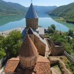
The church itself is a working Georgian Orthodox monastery dating to the 14th century. Shoulders and knees must be covered to enter. The view of Mount Kazbek from the churchyard on a clear morning — the summit catching the first light while the valley below stays in blue shadow — is one of the most photographed scenes in the entire Caucasus, and it earns every photograph taken of it.

Juta Valley and the Chaukhi Pass: The Best Scenery Beyond the Crowds
Juta is a small village about 12 kilometres southeast of Stepantsminda by road, and the hiking country above it is sharply different from the Kazbek side. The Chaukhi massif — a jagged series of dolomite towers that rise above 3,800 metres — provides a backdrop that stops people mid-stride. The valley itself is quieter than the Gergeti circuit even in peak season.
The most popular route from Juta follows the Chaukhi Gorge trail to the base of the towers, a relatively straightforward hike of about 8 kilometres one way with 700 metres of elevation gain. Allow 3–4 hours up and 2.5–3 hours down. The trail is well-marked above Juta village and follows the river before climbing into open alpine terrain above the treeline. In late June and July, the meadows between 2,200 and 2,600 metres are thick with wildflowers — yellow buttercups and purple alpine gentians cover ground that was snowfield two weeks earlier.
Chaukhi Pass itself, at approximately 3,338 metres, is a full-day objective from Juta. Strong hikers do it in 5–6 hours up and 4 hours down. The pass connects to the Roshka Valley on the far side, which is in the Gudamakari region — this is the key waypoint for the multi-day traverse described later in this guide.
Getting to Juta: marshrutkas and shared taxis run from Stepantsminda in summer, typically leaving in the morning when enough passengers have gathered. The fare is around 15–20 GEL per person each way in 2026. Private taxis charge 60–80 GEL for the vehicle.
Gveleti Waterfalls and the Truso Gorge: Lower-Altitude Alternatives
Not every day in Kazbegi needs to involve 1,000 metres of climbing. These two routes are ideal for acclimatization days, for hikers who prefer less elevation gain, or for visits in early May or late October when the high passes still carry snow.

Gveleti Waterfalls sit in a side gorge off the Dariali Valley, about 8 kilometres north of Stepantsminda toward the Russian border. The trail from the roadside parking area to the lower waterfall is barely a kilometre and almost flat — the falls crash down from about 30 metres, and the spray carries far enough that you’ll feel it before you see the water. The upper waterfall requires a steeper 30-minute scramble on a rougher path. The round trip including both falls takes 2–3 hours. Note that the Dariali border zone has access restrictions and the checkpoint position changes — in 2026, the waterfall access point remains on the Georgian side without any special permit.
Truso Gorge is one of the most visually unusual landscapes in the entire Kazbegi region. The Terek River carved this gorge through volcanic rock, and cold mineral springs have deposited ochre and rust-red travertine formations along the riverbank — the colours look almost artificial against the grey stone walls. The gorge runs roughly 15 kilometres into the mountains toward the South Ossetia administrative boundary line, though the trail for standard hikers ends well before that point at the ruins of the medieval Zakagori fortress. The walk to Zakagori and back from the gorge entrance road is about 20 kilometres and takes 6–7 hours. Bring more water than you think you need — the mineral water from the springs looks drinkable and locals do drink it, but it has a strong iron taste.
The Arsha–Gudauri Ridge Trail: Kazbegi’s Underrated Long Walk
Almost nobody talks about this route in the mainstream travel coverage of Kazbegi, which is precisely why it’s worth covering. The trail begins in Arsha village, about 10 kilometres south of Stepantsminda on the Georgian Military Highway, and climbs southeast to the ridge system that sits above the ski resort town of Gudauri. It is effectively a linear high-ridge traverse connecting two of the most visited points on the Military Highway, but done from an angle that almost all tourists never use.

The full route is approximately 22 kilometres point-to-point, with a total elevation gain of around 900 metres to the ridge and then a long descent to Gudauri. It requires arranging transport at both ends — a taxi to Arsha from Stepantsminda (around 30–40 GEL) and a pickup from Gudauri, or simply walking down to the main road and catching a marshrutka. Total hiking time for fit walkers: 7–9 hours. The ridge section between 2,600 and 2,800 metres gives unobstructed views in both directions — the Kazbek massif to the north, the Khada Valley below, and on clear days the jagged line of peaks extending west.
Multi-Day Routes: The Kazbegi–Sno–Juta Circuit
For hikers with 3–5 days and the gear to camp overnight, the circular route linking Stepantsminda, the Sno Valley, Juta, and the return via Chaukhi Pass is the definitive Kazbegi backcountry experience. It combines river valley walking, high-pass crossings, remote meadows, and the kind of silence that is genuinely hard to find in Georgia during peak summer.
A typical itinerary runs: Day 1 — Stepantsminda to Sno Valley, camping near the river at around 1,900 metres (18 km, moderate). Day 2 — Sno to Juta via the valley trail (10 km, easy, short day intentionally to allow afternoon rest). Day 3 — Juta to Chaukhi Pass and descent to Roshka (14 km, strenuous, start early). Day 4 — Roshka back to Stepantsminda via vehicle road or trail option (transport available from Roshka).
Wild camping rules in 2026: Camping is permitted in designated zones within the Kazbegi Protected Area. Fires are prohibited above 2,000 metres — this is actively enforced. Gas stoves are the only legal option for cooking at altitude. Designated camp zones are marked on the Gaia GPS and Maps.me layers updated for Georgia in 2025. Camping outside designated zones can result in a fine of 100–200 GEL.
Honest Trail Difficulty Ratings
Georgian hiking routes are often graded inconsistently across different sources. Here is a straightforward breakdown using elevation, distance, and terrain rather than vague adjectives:
- Gveleti Lower Waterfall: Easy. 2 km, 60m gain. No technical sections. Suitable for any fitness level.
- Gergeti Trinity Church (direct): Moderate-strenuous. 5 km round trip, 500m gain. Steep sections on loose rock. Allow extra time at altitude.
- Juta to Chaukhi Base: Moderate. 16 km round trip, 700m gain. Clear path, no scrambling, long but not technical.
- Truso Gorge to Zakagori: Moderate. 20 km round trip, 350m gain. Distance is the main challenge, not elevation.
- Chaukhi Pass from Juta: Strenuous. 22 km round trip, 1,200m gain. Some rocky sections near the pass, exposure to weather.
- Arsha–Gudauri Ridge: Strenuous. 22 km point-to-point, 900m gain. Navigation skills required on ridge sections, no services.
- Kazbegi–Sno–Juta Circuit (3-4 day): Challenging. Multi-day, Chaukhi Pass crossing, requires camping gear and navigation.
What to Pack for Kazbegi Trails in 2026
The single most common mistake on Kazbegi trails is underpacking for weather. The second most common is overpacking everything else. Here is what genuinely matters:
- Waterproof outer layer: Not water-resistant — waterproof. Afternoon storms are fast and heavy.
- Warm mid-layer: Fleece or insulated jacket. Even in July, above 2,500 metres the wind cuts through.
- Trail shoes or boots: Waterproof hiking boots for anything above the Gergeti Church trail. Trail runners are sufficient for Gveleti and Truso only.
- Trekking poles: Genuinely useful on the steep descent from Gergeti and on rocky terrain near Chaukhi Pass.
- Water: minimum 2 litres per person for any route over 10 km. Add a filter or purification tablets for stream water on multi-day routes.
- Sun protection: At altitude the UV index is significantly higher than at sea level. A hat, sunscreen, and sunglasses are not optional above 2,000 metres.
- Offline maps: Download the Kazbegi region on Maps.me or Gaia GPS before leaving Stepantsminda. Mobile signal disappears on most routes above the main valley.
- Emergency contact plan: Leave your route and expected return time with your guesthouse. Mountain Rescue Georgia’s number in 2026 is 1233.
Gear rental in Stepantsminda has improved considerably. As of 2026, at least four guesthouses and two dedicated rental shops near the main square offer trekking poles, sleeping bags, and basic rain gear. Expect to pay 15–30 GEL per item per day.
Guided Versus Independent Hiking
Most day hikes in Kazbegi are straightforward enough for experienced independent hikers with good navigation skills and proper gear. The Gergeti Church trail, Gveleti Waterfalls, Truso Gorge, and the Juta to Chaukhi base route are all well-marked and frequently traveled.
A guide makes real sense in three situations: you are attempting Chaukhi Pass or the full multi-day circuit for the first time; weather conditions are unstable and you don’t have mountain experience; or you’re a solo traveler on a remote route where an injury without backup would be genuinely dangerous.
In Stepantsminda, licensed guides can be found through the Kazbegi Protected Area visitor centre on the main road, through several established guesthouses, and via the Georgian Mountain Guide Association, which updated its licensing requirements in 2025. Day guide rates in 2026 run from 120 to 200 GEL per day for a group of up to four people, depending on route difficulty. Multi-day guide rates including logistics assistance run from 200 to 350 GEL per day. Be cautious of very cheap “guides” who are simply offering to walk with you — the difference matters most in an emergency.
2026 Budget Breakdown for Kazbegi Hiking
These are realistic 2026 figures based on current trail fees, transport, food, and accommodation in Stepantsminda.
Budget Tier (self-guided, guesthouse dormitory, cooking some meals)
- Guesthouse dormitory bed: 40–60 GEL per night
- Trail permit registration: 0–10 GEL (most Kazbegi trails remain free in 2026; Chaukhi zone registration is 5 GEL)
- Marshrutka Tbilisi–Stepantsminda return: 50–60 GEL total
- Food per day in guesthouses/basic cafes: 30–50 GEL
- Gear rental if needed: 20–40 GEL per day
- Estimated daily cost on the ground: 90–150 GEL
Mid-Range Tier (private room, restaurant meals, occasional private taxi)
- Private guesthouse room: 100–180 GEL per night
- Meals at sit-down restaurants: 60–90 GEL per day
- Private transport to Juta or Truso: 60–80 GEL per trip
- Day guide for one difficult route: 120–200 GEL split across group
- Estimated daily cost on the ground: 250–380 GEL
Comfortable Tier (boutique hotel, full guiding, private transfers)
- Boutique hotel or upscale guesthouse: 250–450 GEL per night
- Private driver for full day: 150–200 GEL
- Multi-day certified guide: 200–350 GEL per day
- Estimated daily cost on the ground: 600–1,000 GEL
Frequently Asked Questions
How hard is the hike to Gergeti Trinity Church?
It is moderate to strenuous, not easy. The direct trail gains 500 metres of elevation in about 2.5 kilometres — steep, and harder at altitude. Most reasonably fit people complete it in 1.5 to 2.5 hours. If you drove up from Tbilisi that morning, take the longer route via Gergeti village and go slowly.
Do I need a permit to hike in Kazbegi in 2026?
Most trails are free and open, but registration is now required via the Georgian Protected Areas portal. The Chaukhi zone carries a 5 GEL fee. Rangers actively check registration at key trailheads including Juta and Truso. The online process takes five minutes and a screenshot on your phone is sufficient proof.
What is the best month to hike in Kazbegi?
Late June through mid-September offers the most reliable conditions. July and August have the clearest high-alpine access but also the most afternoon thunderstorms. Late September is quieter and cooler with excellent visibility, but high passes like Chaukhi can already carry fresh snow. May and early June work well for lower-altitude routes like Truso and Gveleti.
Is it safe to hike alone in Kazbegi?
Solo hiking on the main day trails — Gergeti Church, Gveleti, Truso — is generally fine during daylight in summer. Solo hiking on remote multi-day routes like the Chaukhi circuit carries real risk if weather turns or injury occurs. Always leave your route and return time with your guesthouse, carry offline maps, and know the mountain rescue number: 1233.
Can you see Mount Kazbek clearly from the trails?
Yes, but timing matters. The summit is clearest in early morning before clouds build. By noon in summer, cloud cover is common on the peak. The best viewpoints are from the Gergeti Trinity Church churchyard, the Juta Valley upper meadows, and the Arsha–Gudauri ridge. Start early for the best chance of a clear summit view.
📷 Featured image by Aleksandr Popov on Unsplash.